|
Welcome to my Fairford Branch Line website. I hope it will bring back memories for anyone that knew the former Great Western branch line in its heyday and give a flavour of
what it was like for those too young to remember it. Running for 22 miles through the beautiful upper Thames Valley, the line was constructed in two stages by the Witney Railway Company and the East Gloucestershire
Railway Company. It survived until 1962, when the whole route was closed to passengers, with the Oxford to Witney section retained for freight. It closed completely in 1970. There have been various suggestions that the
line may be reopened to Witney, and possibly Carterton, but despite the ever increasing congestion on the A40 Witney to Oxford road, this still seems extremely unlikely. As various locations on the original route have
been built on, any new line would have to follow a completely different route.
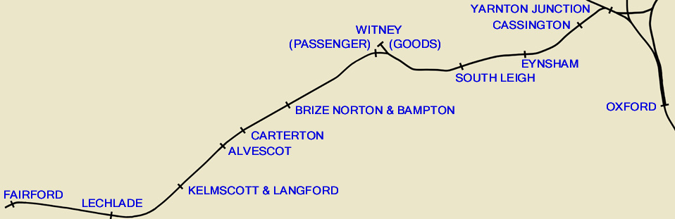
The map below shows the route with all the stations as they were in 1962. You can view further details by clicking on the names on the map, or by using the links at the top of the page. Each page details features visible
along the branch, heading west from the station, except of course, Fairford!
|
|
This website has been primarily designed to show the route of the line in detail with a mix of archive and more recent pictures, including numerous photos taken in 1979/80
when I walked the entire length of the line and much of interest still remained. The site is laid out to assist anyone who wants to investigate the course of the line today. Although most of the buildings have gone,
numerous bridges survive and the actual trackbed is mostly still intact, despite the best efforts of local farmers at assimilating the line into their fields. Ordnance Survey map references are given, but please note
that the description of various features does not indicate a public right of access, and indeed most of the route is now on private land. However all vantage points and footpath crossings are mentioned and certain
sections are now public rights of way. Although I have included a brief history, more details can be found in the books listed in the bibliography. If you have any comments please contact
me, it would be very interesting to hear from people who have recollections of the line.
Special thanks go to Stanley C. Jenkins, who provided much information for this project. Thanks also to Hugh Ballantyne, Jim Barton, Bob Brown, Howard Burchell,
R.M.Casserley, John Church, Tony Doyle, Pete Dorward, Bill Gysin, Simon Glidewell, Malcolm Henderson, Keith Jones, Russell Leitch, D. Loveday, Ian MacEwan, Colin Moulden, Owen Nicholls, Dave Oakey, Malcolm Osmundson,
Kenneth Potter, Peter Reeves, Gerald T. Robinson, Norman Simmons, Mr & Mrs Stewart-Wood, Paul Strong, Steve Thompson, Dorothy Waters, Ron White (Colour Rail) & the late John Strange. All pictures remain the
property of the individual photographers, and must not be used for any commercial purpose without my prior permission. The website will be regularly updated, as and when I acquire additional archive pictures.
I am always on the lookout for more pictures to add to the site, and I am especially keen to see any views from unusual locations. Trains crossing the Evenlode bridge, the
view from the A4141 (now the B4044) bridge near Eynsham, and Calcroft Lane bridge between Alvescot and Kelmscott are particularly sought after. In fact any picture taken from one of the bridges situated between stations
would be very welcome, although I can understand that they might well be unidentifiable. It is surprising how many pictures keep coming to light, and a quite number of them are in colour. With Kodachrome film having an
ASA rating of only 8 until 1961, railway photography could be a little challenging!
|