|
THE FAIRFORD BRANCH LINE |
|
|
|
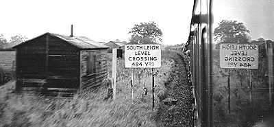
SOUTH LEIGH |
|
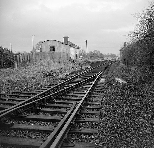
South Leigh station (SP396082) was situated 5 miles 37 chains from Yarnton and had another of the original Witney Railway Co wooden station buildings, only on a slightly smaller scale
than either Eynsham or Witney. A single goods loop was provided but there was no goods shed or even a yard crane. Signaling was equally basic: three ground frames controlled the points and adjacent level crossing, there
being no conventional semaphore signals. During the Second World War a large food buffer store was built just to the west of the station and a rail connection was laid into the goods loop. These buildings can still be seen
today (SP395082). The road to Stanton Harcourt crossed the line at the east end of the station by means of a level crossing.
|
 |
|
South Leigh station building and corrugated iron goods lock up pictured from the approach road side on 15 May 1979, just a few months before they were demolished to make way for a new bungalow. The
station building had been modernised a short time before, and yet planning permission was granted for its removal, without any consideration of its historical interest.
Martin Loader |
|
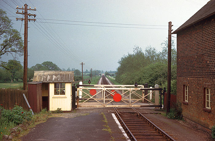
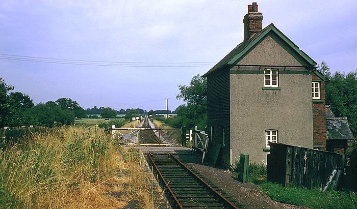
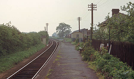
Two views of South Leigh station looking towards Oxford. The early 1960s view (top) contrasts markedly with the 22 September 1972 view (lower), taken nearly a year after the line
closed. In the first picture the crossing and ground frame hut are in good order, and there still appears to be maintenance being undertaken on the line. The fencing on the south side of the line in the distance looks new,
a view reinforced by the presence of some wire spacing rods leaning against the fence. Although not as immaculate as in times past, peonies still thrive in the platform garden. Just over a decade later the peonies have
been smothered by grass and thistles. The grass covered platform and crossing keeper's cottage frame the line of rusting rails disappearing into the distance up South Leigh Bank. During the last years of operation one of
the crossing gates became damaged and was replaced by the two lengths of rope seen here. Note the 10, 20 & 40 wagon length warning boards, giving the driver an indication where to pull up clear of the crossing. The
crossings both here and at Eynsham were padlocked across the line following withdrawal of passengers services, being released by a key attached to the train staff.
Colour Rail & Stanley C Jenkins
|
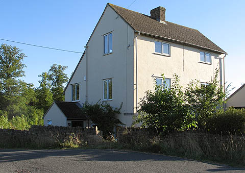 |
South Leigh crossing keepers cottage in Summer 2006. Extensively altered, including the insertion of a couple of first floor windows facing the site of the station, as well as white
rendering covering the original brickwork. The site of the level crossing is marked by the slight hump visible here in the road. Rumours of the rails being still in situ under the tarmac have been disproved with the use
of a metal detector!
Malcolm Osmundson |
|
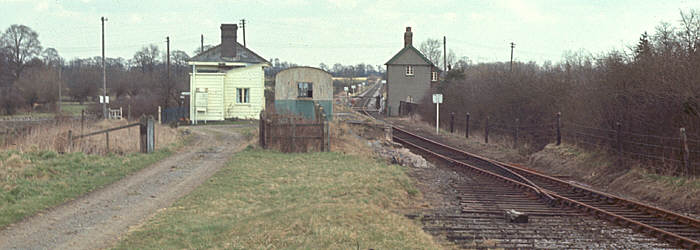
Two views of South Leigh station. The view on the right shows the line in around 1970, looking towards Oxford, whilst the view below is looking towards Witney in the early 1960s. In
addition to the ground frame near the level crossing, South Leigh boasted two others in lieu of a signal box. These can both be seen in this view - the first in the bushes near the point that leads to the small goods
yard, while the furthest one can just be seen next to the large tree in the distance.
Martin Loader Collection & Colour Rail |
 |
 |
|
|
|
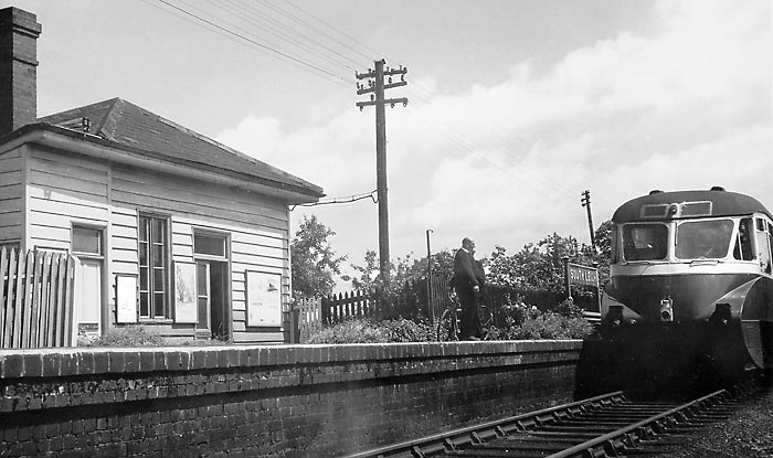
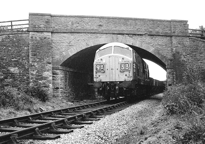
In June 1957 an ex GWR Diesel Railcar pulls away from South Leigh station with the 12:30 Fairford to Oxford service. These pioneer units were by no means common on the branch and
pictures of them in action are quite scarce. This view clearly shows that the station building was designed with the original low platform in mind, as there were steps down into the building from the modern platform. Note
that the booking office notice below the two panes of glass in the door is in fact a third of the way up the door, but appears nearly level with the platform from this angle!
Martin Loader Collection |
 |
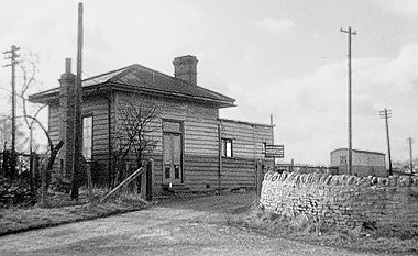
South Leigh station building pictured on 22 September 1972. It survived in use as a private house until it was demolished in 1979 to make way for a new bungalow. The smallest of the
original Witney Railway Company station buildings, accommodation consisted of a waiting room (through the double doors) with adjacent booking office, a small ladies waiting room (through the white door) and a toilet block
(to the left).
Stanley C. Jenkins
|
|
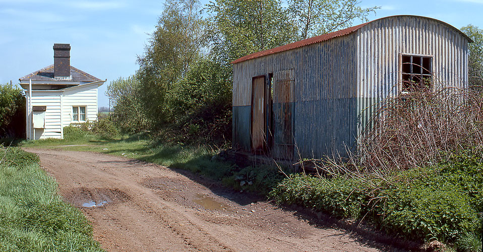
Viewed from the north side, the basic nature of South Leigh station building is even more evident. This type of structure was a Victorian "quick fix" building solution,
using prefabricated components, and at the time used for all manner of semi-permanent buildings. There is no reason to suppose the Witney Railway Company was considering it to be merely temporary, rather the cost was the
deciding factor. This view from the late 1960s also shows the approach road and corrugated iron parcels shed. The station building at this time is obviously in use as a private residence, as a pint of milk can be seen on
the door step!
Stanley C. Jenkins |
|
|
A South Leigh panorama. In early 1970 the siding had been removed, although as can be seen here the point remained in situ. This view taken from the cattle dock area shows the
entire station area, and also the warning boards installed after the line became freight only.
Colour Rail |
|
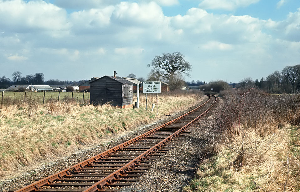
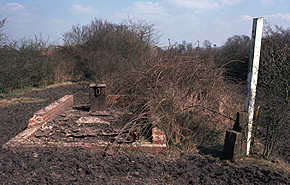
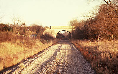
Just to the west of the station (SP393080) there was a wooden permanent way hut on the north side of the line, next to which during the line's last years, a sign warning of the
approach to South Leigh level crossing was erected. In this fine view looking east in early spring 1970, two more signs can also be seen in the distance, and just visible near the tree is the white painted station
building.
Colour Rail |
|
In this 24 May 1969 view from the 'London Division Branch Line Tour' the level crossing warning sign can be seen, along with its nighttime illumination lamp on an adjacent post. On 4
April 1980 only the brick built base of the hut remains, along with the stove, while the post now has no lamp or sign to illuminate.
Stanley C. Jenkins & Martin Loader
|
|
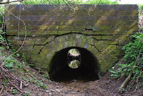
A little further west from South Leigh (SP381080) the line crosses another small stream by means of a standard brick built bridge of 3 feet diameter. Luckily on 7 April 2007 the stream had
dried up sufficiently to allow me to take this picture looking through the arch. Generally the surviving stream bridges and culverts are in good condition, but here it is evident that the entire arch has subsided a
little, leaving cracks between it and the parapet.
Martin Loader |
|
|
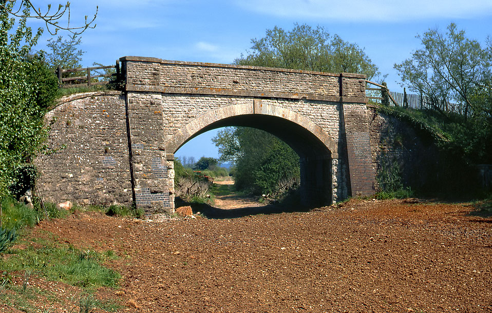
Continuing west from South Leigh, after 1¼ miles the Cogges to Stanton Harcourt road crosses the line by a substantial stone bridge locally known as The "Ballaso"
(SP377080). This was probably a corruption of "ballast hole", for indeed there was a large quarry just to the south of the line which was almost certainly used in the line's construction. The Witney Railway
Company obviously had aspirations that their line would one day become part of an important through route, as this bridge was clearly constructed with double track in mind - alas it was not to be. |
|
|
|
The bridge is pictured (above) looking east on 15 May 1979, just before the owner of the nearby cottage reclaimed the trackbed for a garden (note the freshly leveled soil in the
foreground). Note that various minor repairs to the bridge have been carried out with blue engineers bricks, rather than stone. The ballast hole from which the bridge presumably takes its name was situated to the right of
the willow trees visible behind the bridge.
Martin Loader |
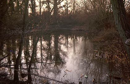 |
The original ballast hole has been filled in and is now a completely open field, which is rather a reversal of the normal situation, where a formerly open trackbed becomes an
impenetrable jungle! It was still a water filled crater surrounded by trees when this photo (left) was taken in the early 1970s. Most of the overbridges on the line at one time had some evidence of excavations nearby to
provide material for the approach embankments. It was only on the former Witney Railway that these were extensive, as the East Gloucestershire Railway's bridges were somewhat skimped in construction by comparison.
Looking at this picture of a gloomy pond surrounded by trees it is easy to understand how the place locally acquired a rather sinister reputation.
Stanley C. Jenkins |
|
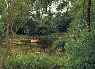
The Ballaso is pictured again on 27 June 1978, shortly before it was filled in. Nowadays the only clue to its existence is the triangular plot of land bounded by the road, old
trackbed and a short farm track that leads between the two. This marks the extent of the former pond. Although something of a haven for wildlife, as can be seen from both these pictures its close proximity to the road
made it an easy dumping ground for various items of domestic rubbish.
Martin Loader |
 |
|
|
|
Class 22 diesel hydraulic 6326 passes beneath the "Ballaso" bridge with a lengthy train of coal wagons during the final year of the line's life. The train is the twice
weekly Hinksey Yard to Witney freight. The track has gone, all the Class 22s have long since been scrapped but the bridge still survives, although it cannot be viewed from this angle, as not only is the land now private
property, but a belt of Leylandii fir trees now block the view.
Stanley C. Jenkins |
 |
The Ballaso is pictured shortly after track lifting from a little further back than the previous two views. Note the clean ballast highlighted here by the low winter sun. Cogges
Bridge Cottage is just out of view to the left.
Stanley C. Jenkins |
|
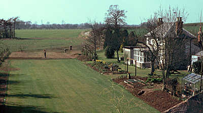
By 4 April 1980 the area in front of Cogges Bridge Cottage had become a lawn, as this view from the "Ballaso" shows. Although the new lawn takes its boundaries from the
old trackbed (note the railway fence on the left), it can clearly be seen that all trace of the line has obliterated beyond the cottage. The Stanton Harcourt to Cogges road can be seen curving to the right in the
background. From the "Ballaso" the line curved to the right, then the approach to Witney was on a straight section of nearly a mile, with the spire of St. Mary's church visible on the horizon.
Martin Loader |
 |
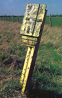 |
Approximately ¾ mile from the "Ballaso", on the approach to Witney, the 74½ milepost is pictured on 4 April 1980 in a very dilapidated state. In
2005 only a few of these posts survive, often being almost invisible in the hedge as the head has usually rotted away. This section of the trackbed approaching Witney has been returned to agriculture, virtually
the entire length between the Ballaso and the Witney by-pass having been incorporated into the surrounding fields.
Martin Loader |
|